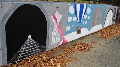
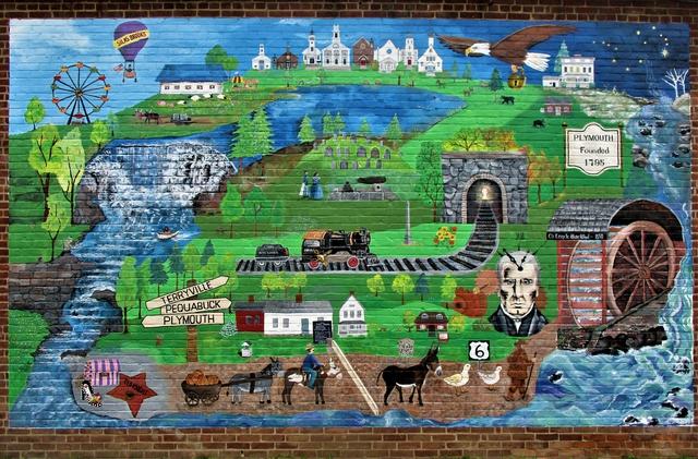
The mural at the Terryville Library portrays important people, places, and events of Plymouth's interesting heritage. An "I Spy" guide was created, allowing visitors to locate pictures on the mural and read about their significance. Visitors can then travel about town to discover the actual locations shown on the mural.
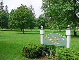 Baldwin Park is on Main Street in downtown Terryville, across from the Lyceum. It was donated by the Baldwin family in 1892. The park is owned and maintained by the Baldwin Park Association, and is open to the public for their enjoyment. It is the site of the summer concert series sponsored by the Plymouth Chamber of Commerce.
There are many interesting trees in the Park, including a Copper Beech planted in 1995 for Plymouth's Bicentennial, a rare Kentucky coffee tree, and a pin oak that was grown from an acorn from the Constitution Oak on the Plymouth Green.
Pictured right is Baldwin Park.
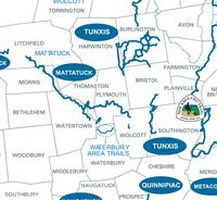 There are over 10 miles of hiking trails in Plymouth that are part of the statewide Blue Trail system maintained by the Connecticut Forest and Park Association (link to www.ctwoodlands.org). The trails include the Mattatuck Trail, the Whitestone Cliffs Trail, and the Tunxis Trail.
The Mattatuck Trail runs through the southern portion of Town for 7.7 miles. This trail can be accessed at Marino Pond off of Wolcott Road, from Town Hill Road, at the end of Todd Hollow Road, and on Carter Road.
The Whitestone Cliffs Trail runs for 1.4 miles through Mattatuck State Forest to a vista that overlooks the Naugatuck Valley.
There is parking off of Route 262.
The Tunxis Trail starts on East Plymouth Road and runs through Bristol Water Department land for a mile before reaching Tory Den, a rock formation where Loyalists hid from the raids of the Sons of Liberty during the Revolutionary War.
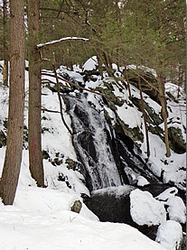 Buttermilk Falls is a lovely series of cascades off of Lane Hill Road. They are easily accessible by following the blue-marked Mattatuck Trail from a pulloff on the side of the road. During the winter, Lane Hill Road is closed, but the trail is only 500 feet from where the road is closed, so the falls can be enjoyed year round.
The GPS coordinates of the access point are N41.64475, W73.00755 The Falls are owned by The Nature Conservancy, and the Mattatuck Trail is maintained by volunteers from the Connecticut Forest and Park Association (www.ctwoodlands.org).
Get out and enjoy Plymouth's beautiful scenery!
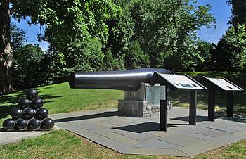 The monument honoring Dorence Atwater, Plymouth's Civil War hero, is on a hill overlooking Baldwin Park. Atwater enlisted in the Union Army, only to be captured and sent to the notorious Confederate prisoner of war camp at Andersonville, Georgia.
While there, he secretly kept a list of 13,000 Union soldiers who died in captivity. After the War, he returned to the prison with Clara Barton and properly identified the dead soldier's graves.
Because of his efforts, the families and friends of the missing soldiers were able to learn the fate of their loved ones.
He was rewarded by being named the American consul to the Seychelle Islands, later was transferred to Tahiti, and married a Polynesian princess. On Memorial Day, 1907, the monument, consisting of a plaque and cannon, was dedicated, with Clara Barton in attendance. Dorence Atwater returned to Terryville in 1908 to see the monument.
He died in 1910 in San Francisco, and is buried in Tahiti.
Disc Golf Course at Terryville High School
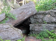 During the Revolutionary War, the hamlet of East Church, in the northeastern part of Plymouth, was populated by people who supported their homeland of England. They were called Loyalists or Tories. Periodically, the local Sons of Liberty would raid their homesteads and farms. The Tories escaped by hiding in a cave deep in the woods called "Tory Den". After the War was over, the residents built St. Matthew's Episcopal Church, completed in 1794.
An old graveyard lies next to the Church.
Today, the Church is a private residence. You can walk to Tory Den by following the Tunxis Trail for about one mile to the cave. The Trail is marked with blue blazes. The entrance to the Trail is about 1/2 mile north of the cemetery on East Plymouth Road. There is parking for several cars. East Church is on the National Register of Historic Places.
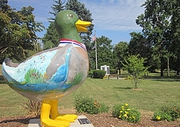 Eli the Duck is part of a public art project sponsored by the Central Connecticut Regional Chamber of Commerce. Area businesses and organizations sponsored fiberglass ducks decorated by local artists to beautify business districts and build a sense of community in the region. In Plymouth, the Chamber of Commerce sponsored Eli,and it is located at Baldwin Park by the Chamber sign (winter home in the Town Hall Front Vestibule.). Other ducks can be seen at Thomaston Savings Bank and New England Bank.
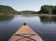 Hancock Brook Lake is a floodcontrol area managed by the Army Corps of Engineers. Located in the southern part of Plymouth, it totals 721 acres, including a 40-acre reservoir that is ideal for kayaking, canoeing, and fishing. Herons and beavers can often be seen here. Access to the reservoir is from the south end of the property at the dam off of Greystone Road.
The Corps leases a small soccer field downstream of the dam to the Terryville Youth Soccer League. The north end of the Flood Control Area can be accessed from the end of Todd Hollow Road, where there is plenty of parking. Be aware that the gate closes at sunset. This section is used for hiking, dog walking, and hunting, especially for waterfowl in the numerous marshes. The Mattatuck Trail, part of the statewide Blue Trail system maintained by the Connecticut Forest and Park Association, runs through this section.
A model airplane club leases a field in this area where you may see them in action on weekends. The Hancock Brook Lake flood control area is located next to the Mattatuck State Forest and the Boy Scout-owned Camp Mattatuck, comprising a large area of open space in the southern part of Town. The Army Corps of Engineers website for Hancock Brook Lake.
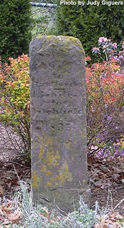 In 1835, a highway mile marker to Hartford was placed on the south side of Main Street, near the present Bristol town line (corner of Bushnell Street), signifying that Route 6 has been a well traveled roadway for a long time. The marker specifies the distance to Hartford and Litchfield. Often, tolls were collected at these sites.
This marker is made of brownstone and looks a bit like an old tombstone. It is roughly carved and very weathered. It is inscribed:
19 Miles to Hartford
13 Miles to Litchfield
1835
The date of 1835 is confusing as other records state that the marker was placed in 1815, just a few years after the incorporation of the Town of Plymouth in 1795.
This particular marker has been allotted a special place in Plymouth with respect to its place in our history. As you can see from the photo, the town has graciously landscaped around this historical remnant of the early days of Plymouth and our nation.
Written by Judy Giguere, Town Historian
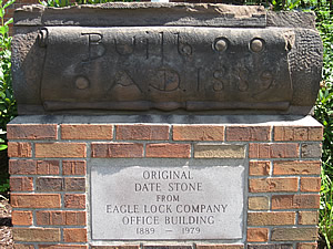
 In 1851, Eli Terry built a dam on the Pequabuck River to supply water power for a new factory, the Terryville Manufacturing Company. Located on Canal Street, the shop made clocks and clock parts. Water from the pond was diverted down a canal to turn a water wheel that generated 35 horsepower at full speed. In 1864, the factory became the Eagle Bit and Buckle Company, manufacturers of harness bits and buckles for the Union Army during the Civil War. Eventually, locks for mailbag pouches were made here. Later a sawmill occupied the site, and by 1908, it was a woodturning plant
(Charles Allen Woodturning) that made handles for all sorts of carpentry tools, such as braces, files, and mallets. They also made gavels and wooden spigots for barrels, as well as furniture knobs. A waterwheel powered the shop until 1913 when it was replaced by an electric motor. Today, the site of the original factory is the home of Lassy Technical Machining, LLC, continuing Plymouth's rich industrial heritage.
The bridge on Canal Street that provides this view of the Falls is named after Ted Knight, who starred in the Mary Tyler Moore Show in the 1970s and in the popular film "Caddyshack". He grew up on nearby Allen Street.
 Lake Winfield is one of Plymouth's most popular recreational facilities. There are a total of 33 acres to explore, including a 16-acre lake for fishing and non-motorized boating (canoeing and kayaking), encircled by a 0.8 mile walking path. Other park amenities include a playscape, picnic gazebo, two tennis courts, and two pickleball courts. Contact P&R at ParksandRec@plymouthct.us to access portable pickleball nets. There is no swimming at Lake Winfield.
Parking is available off of Holt Street and at Seymour Road.
The Lock Museum of America is at 230 Main Street, across the street from the original location of the Eagle Lock factory, founded in 1854. It has been featured in many travel guides for those seeking unusual sites off the beaten path.
The Museum houses an extensive lock collection that includes a Cannon Ball Safe, 30 early era time locks, a large number of British Safe Locks, Door Locks, Padlocks, Handcuffs and Keys, and more.
 The Eagle Lock Room contains over 1,000 locks and keys manufactured from 1854 to 1954. The Bank Lock Room comprises a selection of bank locks, vault locks, safe locks and time locks. The Corbin-Russwin Room contains a large display of ornate hardware. Several pieces are gold plated and enameled. One of the animated displays shows how a pin tumbler lock works.
A large display of mounted door knobs and escutcheons made by Russwin and P & F Corbin during the Victorian era are extensively detailed in styles such as Roman, Greek, French and Italian Renaissance, Gothic, Flemish, and Elizabethan English. The Yale Room accommodates locks manufactured from 1860 to 1950. One of the attractions here is the original patent model of the Mortise Cylinder Pin Tumbler Lock designed by Linus Yale Jr., in 1865.
While this device is considered the greatest invention in the history of lockmaking, it is certainly not without historical precedent. Close by is a 4,000 year old Egyptian made pin tumbler lock! The Antique Lock Room contains a large display of colonial locks and Ornate European Locks dating back to the 1500s. The museum is a fascinating look at the technology used over the centuries to "keep honest people honest".
For more information, www.lockmuseumofamerica.org
Roughly nine hundred acres of Mattatuck State Forest are in Plymouth. The Forest is open to many kinds of outdoor recreation, including hunting, hiking, and birdwatching. The Mattatuck Trail runs through the Forest. The Whitestone Cliffs, located off of Rt. 262, are a popular rock climbing area. Dirt bikes and ATVs are not allowed on the State Forest.
The Old Cemetery at the corner of South Main Street and Agney Avenue has the gravestones of Eli Terry and his son, Eli Terry, Jr., for whom Terryville is named. Many individuals associated with the Eagle Lock Company and the Water Wheel are also buried here.
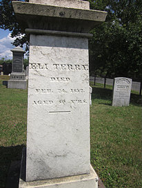
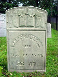
"ELI TERRY DIED FEB. 24, 1852. AGED 80 YRS." "ELI TERRY, JR. DIED May 21, 1811: Æ. 42."
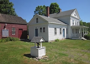 The Plymouth Historical Society is located at 572 Main Street. It has two buildings, the Toll House Museum and the Alley House Museum. The maroon-painted toll house was built in the early 1800s and was the home of the tollkeeper on the Hartford - Litchfield Turnpike. Inside the toll house is the completely restored 1852 Woodruff and Beach steam engine. It powered the Shelton and Tuttle carriage shop on Main Street in the mid-1800s.
This is the only engine of its kind in the United States. The Alley House museum, a white Greek Revival house built by Augustus Shelton in the mid-1800s, contains a collection of Plymouth memorabilia, including items from the Civil War.
Both houses are open to the public on Plymouth Heritage Day, when visitors can hear the piercing cry of the steam whistle when the steam engine is fired up. The Historical Society also has other exhibits several times a year. For more information about the Society, go to www.plymouthhistoricalsociety.org.
 The Plymouth Land Trust owns almost 75 acres in Plymouth. The 30-acre Leach Stanton parcel has trail access on North and Main Streets. It is included in the "Walking Tour of Plymouth Center". The trail passes by Sunset Rock, with views overlooking Peat Swamp, and the stone foundations of the 1850-era Shelton Tuttle Carriage Factory.
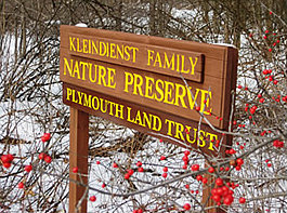
The Land Trust also owns the Kleindienst Preserve on Armbruster Road, which has a level 1/2-mile trail ideal for small children.
All trails on Land Trust property are marked with white blazes and are open to the public free of charge.
For more information, go to www.plymouthlandtrust.org
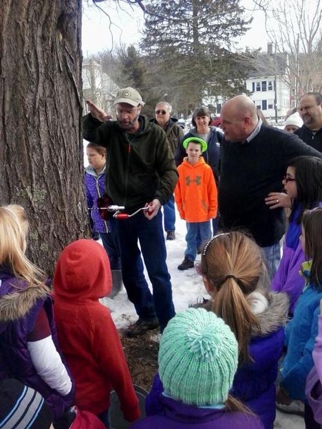
The Plymouth Maple Festival is held on the first weekend in March on the Green, 10 Park St., Plymouth. Celebrate the New England tradition of making maple syrup. Discover how to identify sugar maples, use an old fashioned drill to tap them, insert the spiles, hang the buckets, watch the sap drip out. Listen for the pinging sound of sap hitting the metal pail. Watch sap being boiled into syrup on an outdoor fire. Sample maple sugar and sugar on snow. Maple baked beans and maple ham available for lunch.
CT-grown products such as maple syrup and maple sugar candy will also be sold. If there's snow, make a snowman! Lots of fun kids activities.
All events take place on the beautiful Plymouth Green, a traditional New England village listed on the National Register of Historic Places. Admission is free.
Located on Town Hill Road, the Fairgrounds are owned and operated by the Terryville Lions Club. Many events are scheduled throughout the year, including the Terryville Flea Market, Terryville Bike Swap, July Tractor Pull, Bug-a-Fair VW Car Show, Columbus Day Weekend Campout, and the Halloween Party.
The most popular festival is the Terryville Country Fair, held on the last full weekend of August before Labor Day weekend.
Thousands flock to the Fairgrounds to hear great music, eat terrific food, see agricultural exhibits, and watch the fireworks.
For more information, go to www.terryvillefair.org

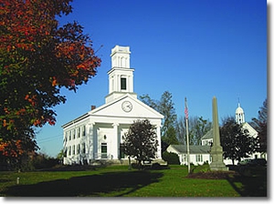
The Terryville Library traces its history to 1839. In fact, Eli Terry was one of the founders. The present day Colonial structure (pictured) was built in 1922. In 1976, the addition was dedicated.
More information about the library can be found at www.terryvillepl.info.
 A Walking Guide to Baldwin Park and Hillside Cemetery
Downtown Terryville is home to a surprising number of especially large and unique trees. On the grounds of the Eli Terry, Jr. Middle School are Ginkgos (a tree that was around when dinosaurs walked the planet), a Japanese Umbrella Pine (the 6th largest in Connecticut) and a towering Concolor Fir, the biggest in the state.
Baldwin Park features a Kentucky Coffeetree (the seeds were used by Civil War soldiers to make a coffee-like drink), and a European Beech planted for Plymouth's Bicentennial celebration in 1995.
Hillside Cemetery has walking paths that are bordered by many trees on the Notable Trees list of Connecticut, including the state's largest Port Orford Cedar, the biggest Austrian Pine, and the second largest Norway Spruce.
Go out and enjoy Terryville's "downtown arboretum".
for the Terryville Tree Tour brochure. Hard copies are also available at the Town Hall and many businesses around town.
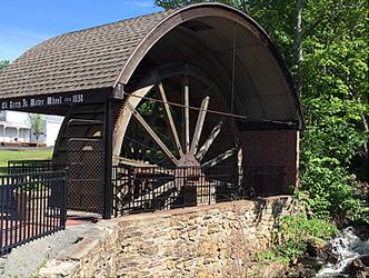 The Terryville Waterwheel is a 20-foot diameter wood and iron structure dating to 1851. The wheel is on the west bank of the Pequabuck River on Main Street in Terryville. Originally, the wheel was enclosed by a small gable-roofed building attached to the main mill. This factory eventually became the Eagle Lock Company.
The Terryville Waterwheel is the most nearly intact of the three known 19th-century wooden waterwheels remaining in Connecticut. It is an evocative monument to Connecticut’s early years of industrialization, when production of clocks, hardware, and textiles relied in whole or in part on waterpower.
The Waterwheel is on the National Register of Historic Places. The Town is creating an educational park to highlight the heritage of this area. A visit to the Waterwheel and the nearby Lock Museum of America show us how "Yankee ingenuity" symbolizes innovation and industriousness.
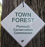
The Town Forest is a 53-acre woodland that was donated to the Town as open space for the Plymouth Heights subdivision. The Forest is located near the end of Watchtower Road, about 0.3 miles from the intersection with Mt. Tobe Road. The town owns a 50' wide right-of-way between two houses for access. Look for a weatherbeaten sign at the trail entrance.
A 1-mile hiking trail, marked with white blazes, leads from the entrance sign into the forest. The first half of the trail goes downhill, and the last half is uphill, but not excessively so. But you'll work up a sweat, so be prepared.
The Town Forest is not well known, but it is a beautiful place for a hike.
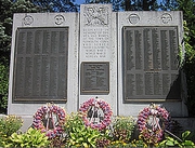 The Veterans Memorial is located in the western end of Baldwin Park, where the Terryville Memorial Day parade ceremonies are held. The flowers are planted and maintained by the Beautification Committee. The monuments deserve our utmost respect and care to honor the memories of those that served our country.
 Take a stroll in the village of Plymouth Center, listed in the National Register of Historic Places. The self-guided walk features the Burying Ground (with gravestones of 38 soldiers from the Revolutionary War), a house where George Washington stayed on his way to meet the Comte de Rochambeau, the Greek Revival Congregational Church built in 1838, a house that was a stop on the Underground Railroad, and the Plymouth Land Trust’s new Carriage Shop Trail.
The full color "Walking Tour of Plymouth Center" brochure includes a map of Plymouth Center, and a list of unique places to see throughout town, including historic sites, outdoor recreation, and local farms.
The Whitestone Cliffs are in Mattatuck State Forest in the southwestern part of town. The granite outcrops are well known among rock climbers. There are beautiful views of the Naugatuck Valley. There is a parking area on the west side of Rt. 262, about 3.7 miles south of Rt. 6. Hikers can follow the Blue-blazed Trail for about ½-mile that leads to the top of the cliffs. The overlook is at an elevation of 750 feet.